


スーパー地形 - GPS対応地形図アプリ
 |
Latest Version | 4.6.17 |
 |
Update | Apr,27/2025 |
 |
Developer | kashmir3d |
 |
OS | Android 5.0+ |
 |
Category | Maps & Navigation |
 |
Size | 16.7 MB |
 |
Google PlayStore |  |
| Tags: | Maps & Navigation |
-
Latest Version
4.6.17
-
Update
Apr,27/2025
-
Developer
kashmir3d
-
OS
Android 5.0+
-
Category
Maps & Navigation
-
Size
16.7 MB
-
Google PlayStore


 Download(4.6.17)
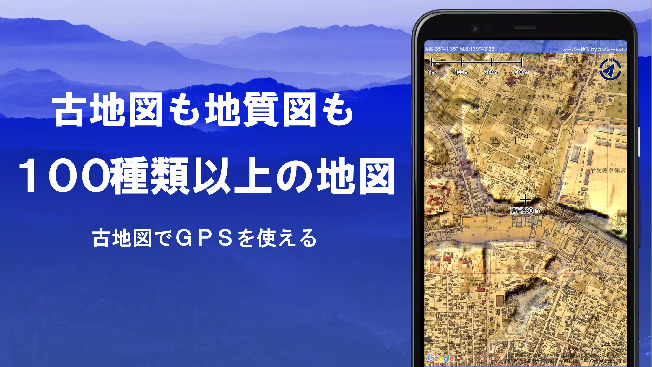
Explore over 100 types of maps, including the renowned Geographical Survey Institute map, to enhance your adventures from mountain climbing to leisurely strolls around town. These maps are designed to maximize the utility of height differences, providing a rich, detailed view of your surroundings.
Proudly awarded the 2018 Japan Cartographic Society Award for Best Work, our app offers an extensive suite of features to elevate your outdoor experience:
- Utilize "super terrain data" that accentuates terrain using our unique technology.
- Access a wide range of maps from the Geospatial Information Authority of Japan, including topographic, geological, old, past and present, and prewar topographic maps.
- Record tracks (trajectories) with the GPS function, with options for GPX log input/output and editing.
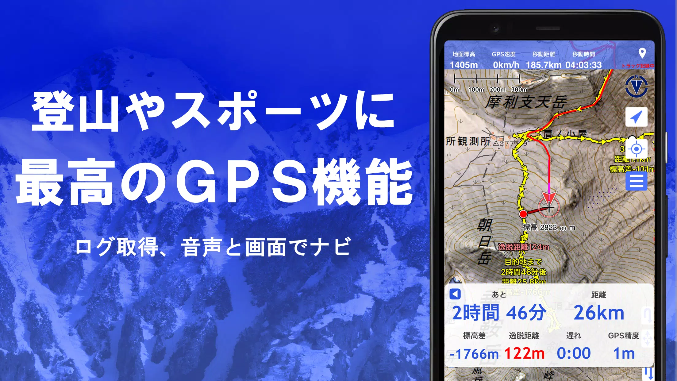
- Benefit from GPS navigation with audio support, perfect for walking around town, mountain climbing, and other outdoor activities.
- Employ the visibility determination function for creating cross-sectional diagrams, aiding in observation and radio communication, with the ability to display buildings.
- Enjoy a 360° panoramic view function for mountain identification and viewing sun, moon, and GPS points.
- Use GPS functionality, bulk map downloads, and a map cache for seamless offline use during mountain climbing or other outdoor pursuits.
- Link photos to specific points for a personalized experience.
- Visualize contour lines generated from elevation data.
- Display the MGRS grid (UTM grid) for precise location mapping.
- Read, display, and edit GIS data from GeoJSON files.
- Create and edit shapes on the map.
- Use the app overseas with ease.
- Generate map prints and PDF outputs.
- Switch to a dark theme for comfortable viewing in various lighting conditions.
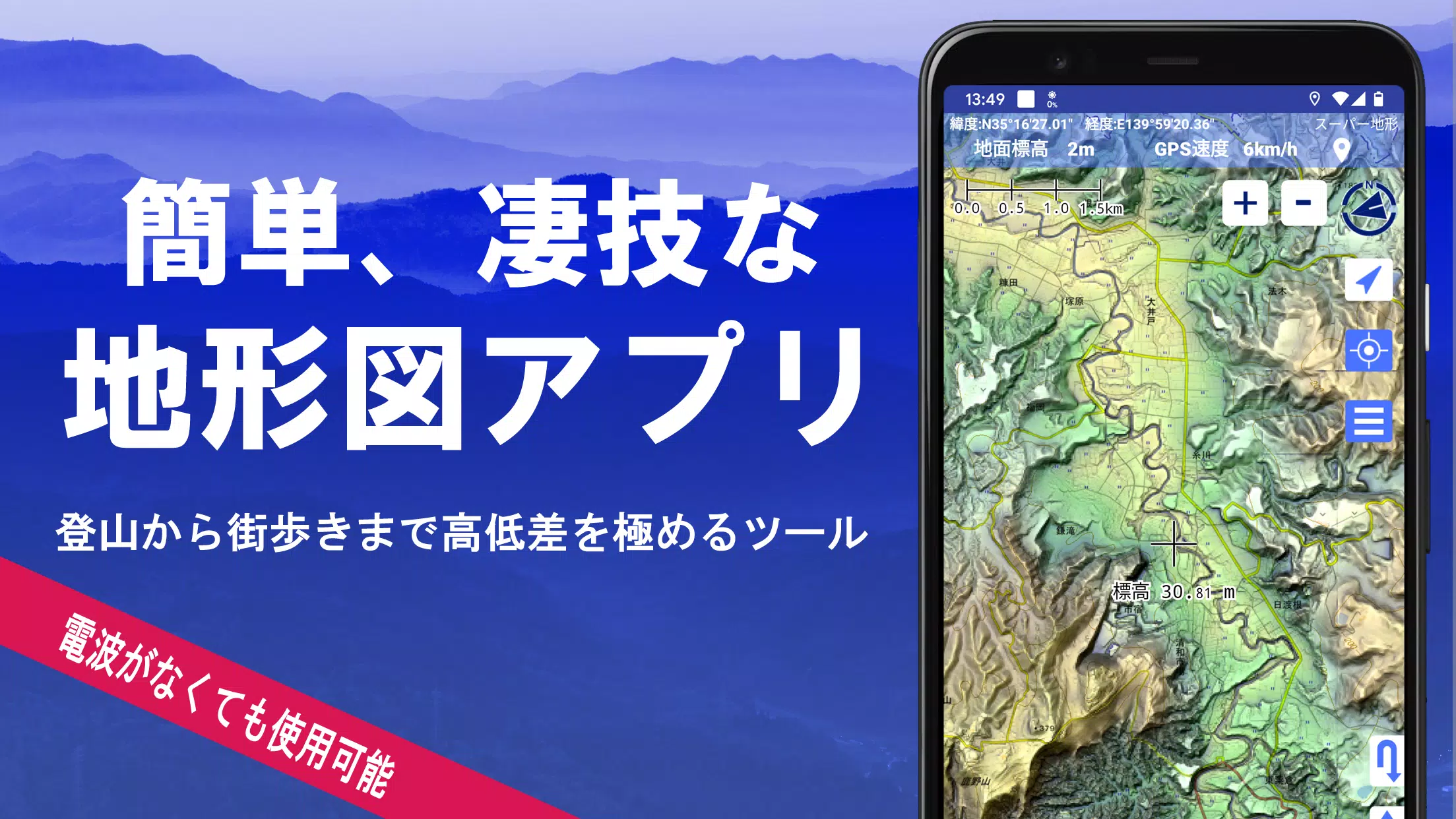
1. A Wealth of Maps at Your Fingertips
Choose from over 100 map types, including our super topographic data and maps from the Geospatial Information Authority of Japan. Note that aerial photographs may have limited availability by age group, with "latest" and "around 1974" offering broader coverage. Enjoy a 5-day free trial of maps using super terrain data upon installing the app.
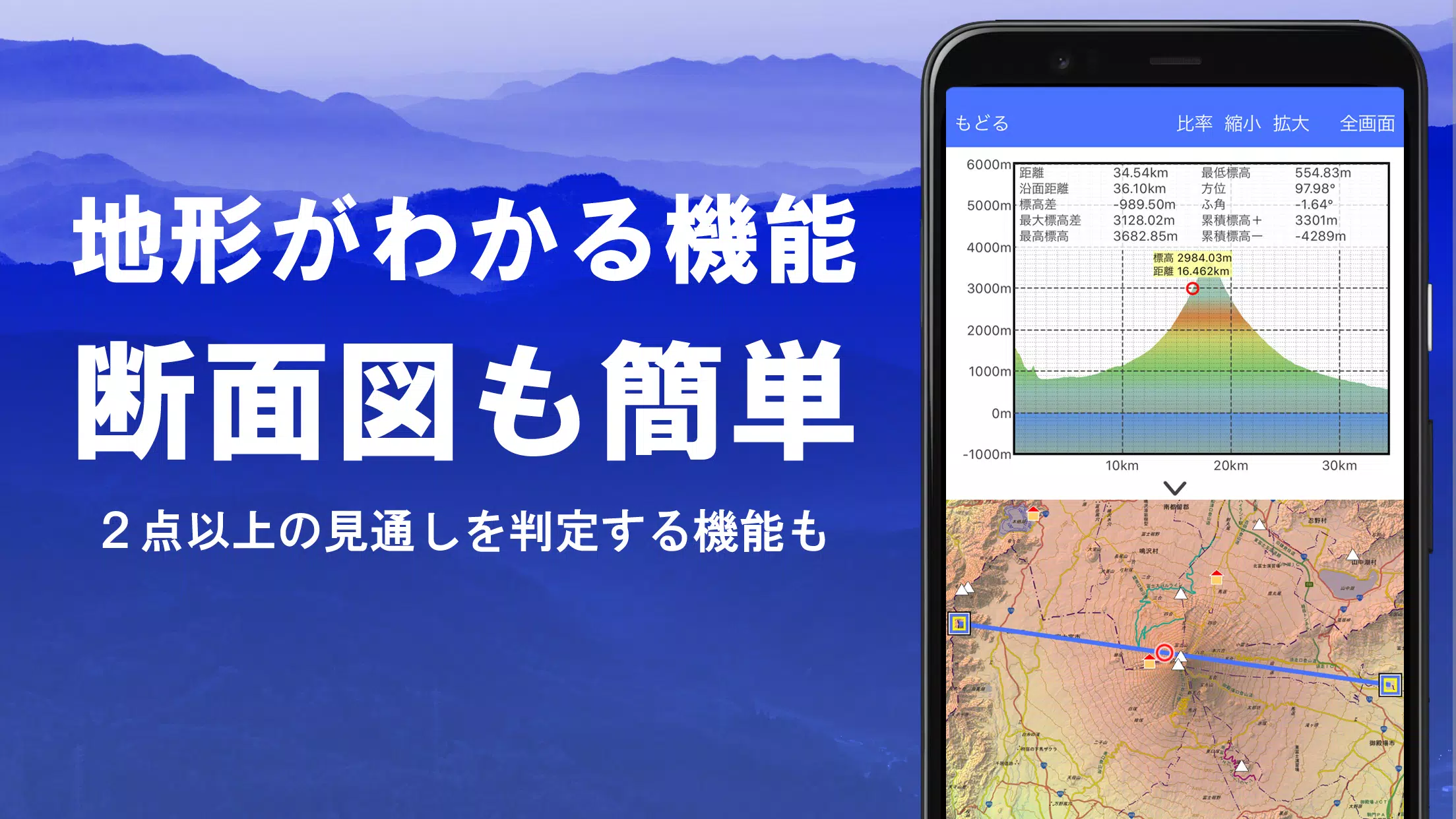
2. Create Cross Sections and Outlooks
Effortlessly draw cross sections through any point on the map. Our app includes the renowned visibility judgment function from Kashmir 3D, accounting for Earth's curvature and atmospheric differences. This feature is invaluable for route planning during climbs, assessing wireless visibility, and understanding terrain. Where available, integrate PLATEAU building data into your cross-sectional views.
3. Elevation Palette Function
Customize your map's background color using the elevation palette function, adjusting the gradation in 1cm increments to suit your preferences.
4. Panoramic View
Experience panoramic observation maps that identify mountains from any location on the map, with a 360-degree view linked to your smartphone's compass. View the sun and moon, including moon phases, to discover Diamond Fuji and Pearl Fuji. Also, view GPS point locations and create panoramic views of mountains abroad.
5. GPS Function
Leverage your smartphone's GPS to obtain location information and record tracks with high-precision positioning, ideal for serious mountain climbing and outdoor activities. Visualize recorded tracks with parameters like elevation, speed, time, and elapsed time. Receive audio and alarm notifications as you approach set points, and display photos linked to specific locations. Send map center positions to NaviCon for seamless navigation.
6. GPS Track Summary Playback
Replay track data comprehensively, with the app automatically displaying photos taken at corresponding times. Tap icons at photo locations to view them.
7. GPS Navigation Function
Navigate along preset tracks with the Track Navi feature, receiving voice or alarm alerts if you stray from the path. This ensures you never lose your way during climbs. Additionally, use route navigation for urban walks and point navigation to reach specific locations.
8. GPS Data Editing Function
Manage GPS-related point, route, and track data in a user-friendly tree format, organized by folders. Create tracks directly on the map and import/export data in GPX format from climbing sites.
9. Map Usage Outside the Service Area (Offline)
Continue using maps even in signal-less areas like mountains, thanks to the bulk download function that ensures all scale maps of the specified plot are available. A cache function further enhances offline usability.
10. Map History Function
The app remembers previously viewed locations, allowing you to return to them easily.
11. Custom Map Compatibility
Import and use custom maps created with Kashmir 3D's map cutter, displaying your own or scanned maps. When using the map cutter, divide each image into approximately 256 x 256 images and send the resulting kmz file to Super Terrain via email or Cloud Drive.
12. GeoJSON Compatibility
Display and edit points, linestrings, and polygons from GeoJSON files, and draw new shapes as needed.
13. Print/PDF Output
Print any map area at a specified scale or create PDFs for detailed records.
14. Cooperation with Other Apps
Exchange GPS data in GPX, KML, and GDB formats with other apps, including the Kashmir 3D software on your PC, and use trajectory data from climbing sites.
15. Backup Function
Securely back up all app data (excluding cached maps) and remove it from your smartphone. Restore data if the app is deleted or your device malfunctions. Utilize automatic backups via Google Drive to maintain up-to-date records. For detailed instructions, refer to the manual.
16. About Billing Function
Some features, such as maps using super terrain data, GPS track functions, and cross-sectional views, require in-app purchases. After payment, place name search results increase. Annual payment is 780 yen/year, with a 5-day free trial upon first installation. To purchase, navigate to [Settings] - [Purchase to remove functional restrictions] within the app. Check and cancel automatic updates via Google Play under "Regular Purchase" - "Super Terrain". Prices may be revised with future enhancements, so early purchase is beneficial.
17. Terms of Use
The copyright holder and developer disclaim responsibility for the outcomes of using this application. Upon first starting GPS, allow the use of location services. Continuous GPS use drains the battery; consider carrying a spare if your device is used for emergency communication. A detailed explanation of the navigation function is available in PDF format at https://www.kashmir3d.com/online/superdemapp/superdem_navi.pdf. Be aware that some smartphones may interrupt or fail to record tracks due to power-saving features closing background apps, a common issue across various applications.